Ayia Napa · Paralimni · Protaras · Gravel
The Coastal of Ayia Napa Tour (City Bikes)
Paralimni, Protaras, Cape Greco and Ayia Napa, back to the shop door.
- 32.6kmDistanceLonger than 9% of our routes.
- 349mClimbingMore than 22% of our routes.
- 10.7m / kmEffortModerate – Hard
- About1 h 49
- Energy610 kcal
- Descending349 m
- Highest point118 m
- Lowest point4 m
- Steepest8.2%
- ShapeLoop
- SurfaceFull tarmac
Energy assumes a 75 kg rider at this pace.
Special edition
Unlock the map and the file
You can already see where it goes and how big it is. What you buy is the detail you need to ride it.
- The route on a real map, zoomable, at full detail
- The elevation profile, with every gradient along it
- Every climb: where it starts, how long, how steep
- The GPX and TCX files for your Garmin or Wahoo
- GPX
- Wahoo, Garmin, Hammerhead, Bryton, Komoot, Strava
- TCX course
- Garmin Edge: the coffee stops arrive as alerts on the road
€5.00
Unlock this routeBuy with an account and this page unlocks for good. Checking out as a guest works too: your files arrive by email.
Suitable for everyone out for a day tour around Ayia Napa, Paralimni and Protaras
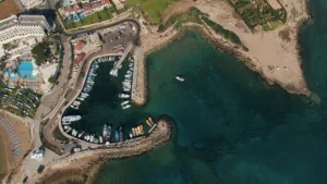

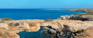
Where it goes
In the order you reach them.- Protaras
- Ayia Napa
- Deryneia
- Paralimni
- Kapparis
How far into the ride each one is comes with the route.
What you ride past
Landmarks within a kilometre of the road.- King Tombs Archeological PlaceAncient site
- Paralimni-NissiaAncient site
- Cyclops CaveCave
- ΓκρέκοSummit
- Entrance to the caveCave
- Ayia Napa International sculpture symposiumMuseum
- Craken CaveCave
- ParadisosBeach
Stops on the way
Every one of these is a named waypoint in the file, so the device tells you it is coming.- 0.0 kmRamo Pro CyclingBike shop
- 6.5 kmProtaras Main RoadCoffee stop
- 10.8 kmKonnos BayViewpoint
- 13.3 kmAgioi AnargyroiViewpoint
- 29.1 kmRefreshmentWater
Place names © OpenStreetMap contributors